
Grand Enchantment Trail: The Ultimate Thru-Hiking Guide (With Map)
The Grand Enchantment Trail offers a remote and beautiful experience in Arizona and New Mexico that will increase your navigation skills. This route finds seldom-used canyons and rugged mountain ranges across the southwest. While it conveniently starts/ends near two major cities for easy transportation – Phoenix and Albuquerque, it is not for the faint of heart.
I recently completed a thru-hike of the Grand Enchantment Trail in the spring of 2023 with my partner. If you’re interested in exploring the southwest but are turned off by the crowds on the Arizona Trail, the roughly 800-mile GET may be a good option for you.
Here you’ll find all the information you need to know before hiking the GET and what we wished we knew beforehand in one ultimate guide.
Without further ado, below are all the major points you need to know before you attempt a thru-hike on the Grand Enchantment Trail.
This post contains affiliate links. I have used every product mentioned, and if you purchase one of these products, I can make a small commission at no cost to you.
List of Contents
Grand Enchantment Trail in a Nutshell: What is it?

The Grand Enchantment Trail is a route that goes from the Superstition Mountains outside of Phoenix, Arizona to the Sandia Mountains outside of Albuquerque, New Mexico.
- Distance. You can vary the distance of the route with different route choices. In many sections, you have a main route option as well as 1-2 other options. You can choose your own adventure on the GET roughly between 725-800 miles.
- Season. Primarily, you’ll want to hike in the spring or fall for a thru-hike. However, if you’re going to section hike, you can do several sections in the summer and several in the winter.
- Resupply. Overall, if you eat anything, you can resupply as you go, especially if you’re willing to hitch longer distances. If you have any dietary restrictions, I recommend sending yourself resupply boxes. We’re vegan, so we did boxes for every resupply. See Our Resupply Strategy Here.
- Water. You should expect to carry water often for 10 to 20-mile stretches. If it’s less, be happy. However, this depends on your start dates, direction, season, and year. More on Water Here.
- Terrain. You’ll explore canyons, wide open rangeland, and traverse mountain ranges. Plant life is spikey.
- Temperature. Weather and temperature can vary drastically. You’ll possibly experience heat into the 100s and cold into the 20s Fahrenheit. This depends on your direction and your start/end dates.
Grand Enchantment Trail Map

As you can see, while it does travel between Phoenix and Albuquerque, the point isn’t the fastest possible route. Rather, it endeavors to explore in a non-direct way.
What’s the Difference Between a Route and a Trail?

While the GET has “trail” in the name, in reality, it is a route.
What’s the difference?
A trail is a regularly maintained path outdoors that travels from point A to point B. It requires very little navigation if you stay on it until you reach a junction. Examples: the Appalachian Trail (AT), the Pacific Crest Trail (PCT), the Arizona Trail (AZT).
A route sometimes uses trails, cross-country navigation, ATV tracks, 2-tracks, 4WD roads, dirt roads, and yes, sometimes even paved roads. Examples: Lowest to Highest Route (L2H) and the Hayduke.
Routes require a greater level of navigation skill. This includes reading topographic lines, reading terrain for the best route of travel, and finding your way back when you get off-route.
Navigation: Phone Apps, GPS, & Paper Map Options


Many long-distance hikers have become accustomed to super easy navigation with the Far Out (formerly Guthook) App. While convenient, it does not feature the Grand Enchantment Trail.
Instead, you must use other, more complicated GPS apps. Primarily, I highly recommend Gaia GPS. It features various map layers that can be downloaded for offline use around a GPS track from Simblissity. I still use the free version, but the paid version is fantastic.
If you have an iPhone, the MapOut App offers a different perspective, although I would not use this as my primary navigation.
Many people now have some version of the Garmin inReach. You can now link this to the Garmin Explore App on your phone and navigate from there as well.
⚠️ Paper Maps on a route like the Grand Enchantment Trail are STILL useful!! ⚠️
The Grand Enchantment Trail has on-map notes. This harks back to pre-Far Out days when everyone carried maps. These on-map notes and the accompanying section guides are extremely helpful! The paper map set comes with the GPS Track.
The Grand Enchantment Trail is NOT just a follow the GPS line experience.
You’re likely to miss out on really cool things or vital information about critical high-water bypasses if you don’t have them.
When to Hike It: Spring vs Fall


The entire Grand Enchantment Trail resides in the American Southwest. This means that the ideal seasons to thru-hike the GET are spring and fall.
If you have about two months available in the spring, you should travel eastbound from Arizona to New Mexico. The Grand Enchantment Trail in Arizona starts in a (relatively) low desert environment. For the first roughly 150 miles, you stay between an average of 1,000 ft- 5,500 ft. This terrain will get hot first and stay hot longer. The first snow you could likely encounter would be in the Graham Mountains.
In contrast, if two months are available in the fall, you should travel westbound from New Mexico to Arizona. The Grand Enchantment Trail in New Mexico starts with several mountain ranges at high altitudes. The Scandia Mountains immediately take you above 10,000ft, and the next several mountain ranges take you to at least 9,000ft. Thus, they will get snow first and hold it longer.
Town Resupply Options Near or On the Grand Enchantment Trail

Click here for your complete Grand Enchantment Trail Resupply Strategy.
Most of the resupply stops along the GET come at regular intervals. However, most are small. Distances between towns vary depending on in-route choices.
Going eastbound, you have these main resupply options:
- Superior, AZ
- Kearney, AZ
- Mammoth, AZ
- Klondyke, AZ
- Safford, AZ
- Morenci, AZ
- Glenwood/Alma, NM (long hitch possibility to Silver City, NM)
- Doc Campbells, NM (long hitch possibility to Silver City, NM)
- Winston/Monticello, NM (long hitch possibility to Truth or Consequences)
- Magdalena/Socorro, NM
- Mountainair, NM
- Tijeras, NM
The towns with legit grocery stores are Kearny, Safford, Morenci, and Socorro. Yes, only 4. And yes, 2 of them are only 60 miles apart.
The other towns have a mixture of Dollar Generals, Family Dollars, local general stores, or nothing.
If you have any dietary restrictions…mail yourself food!
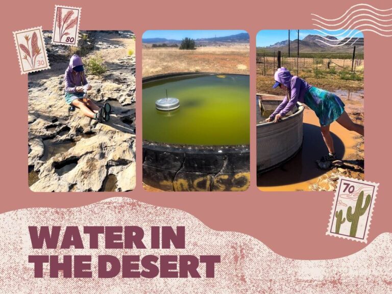
Water Carries and Water Quality


Water carries are definitely a thing on the Grand Enchantment Trail. However, the distance of them depends on several factors.
- Your start date will determine how much water you will have. For example, an early spring start going eastbound will have more water than a later start date. However, you might have more snow and high-water problems if you start too early.
- Wet vs. Dry Winter. For example, in 2022/23, the southwest had a very wet winter. Thus, the spring 2023 season had water and snow much later than in many other years.
- Direction. Spring water depends on the previous winter. Fall water depends on the summer monsoons. Keep your eyes on the weather for 2-4 months before your hike to see if it’s above or below average.
- Cow Grazing Times. Yes, you will drink out of cow troughs. Yes, they can be disgusting. If the cows are not grazing in a particular area, the trough will likely be turned off or empty.
Water quality varies drastically. You will find springs, streams, rivers, spigots, cow troughs, cow tanks, and potholes. Rivers will sometimes have a high level of silt, others will run relatively clear. Cow troughs will sometimes have a float valve or solar well. Other times, they will be totally green and stagnant. Some years you can be picky and some years you cannot.
There is a community updated water report in a Google Sheets Doc as well as historical water data here.
What’s the Grand Enchantment Trail Terrain Like?
If you’ve never been to the southwest, you’re in for a treat! Arizona and New Mexico both have wildly different terrain than movies portray.
Prepare yourself for primarily canyons, rangeland, and mountain ranges. And, mostly without trails. If trails exist, they might not have been maintained in 10, 20, or even 30 years.
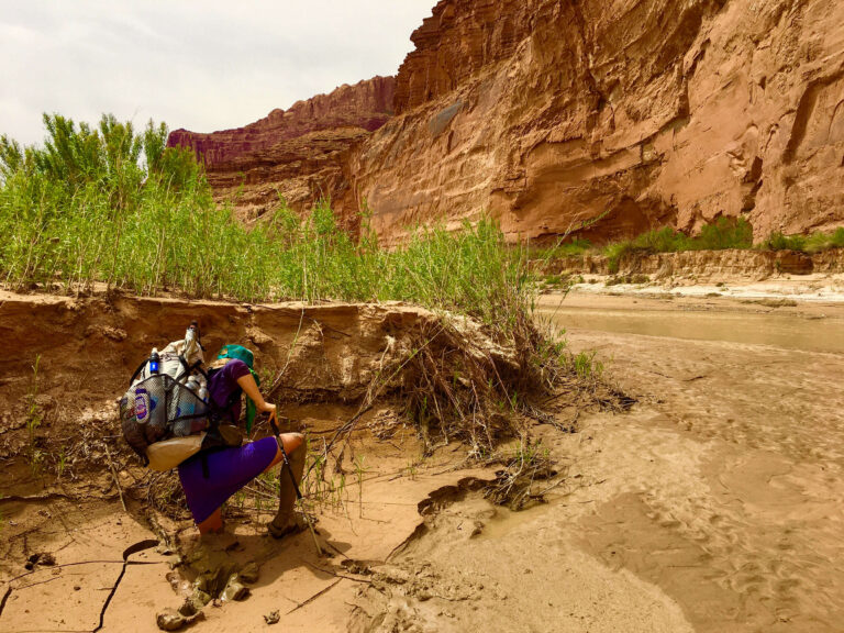
Canyons


Do you love canyons, but are tired of the crowds?
The Grand Enchantment Trail travels through beautiful, remote canyons. But, the trail has another trick…it goes into a popular canyon and then goes further than most ever go.
You will follow rivers up and down, allowing you a break from water carries. Some even offer small pools big enough to submerge yourself.
Rangeland

Are you ready to hone your cross-country navigation skills? The rangeland in between canyons and mountain ranges presents an ideal opportunity.
Yes, you will use all sorts of rancher-made roads, but you’ll often need to cross-country between them. Ranchers make 4WD tracks that suit their needs, and they usually don’t make sense for hikers. The Grand Enchantment Trail will often use one for half a mile, then cross-country a mile to the next one, use it for half a mile, so on and so forth.
Rangeland is also usually checkerboarded. Consequently, you might travel completely legally on one side of a fence, but not another. Thus, you will see notes like “follow fence on south side, climb fence, travel on east side.” If you have your paper maps, you can see the notes on which squares are public and which are private.
Mountain Ranges

Who doesn’t love a good ridge to follow? The GET has several long ridgelines, mainly in New Mexico. However, many of these trails are neglected and/or have suffered several burns since their last maintenance. Thus, you may still find yourself cross-country route finding on what the map shows as a trail.
These mountain ranges might also have snow on them in the early season of spring hiking. One morning, you can be sweating under your umbrella at 10 am, and the next, you can be on a mountain, still in your puffy jacket at 10 am, postholing.
Plant Life Challenges

Everyone says the desert is out to kill you. Sometimes, it is.
Especially a plant called Catclaw, also known as Wait-A-Minute Bush. The Grand Enchantment Trail features catclaw prominently in the first 300 or so miles. The trail organizers recommend pants. We shredded our legs with shorts and my dress, so there is some merit to it.
Other spikey plants to keep your eyes on: all yuccas, cacti, and really, most plants.
Grand Enchantment Trail Summary: Is it right for you?

All that being said, is the Grand Enchantment “Trail” right for you?
If you say yes to the following statements, it’s a good match.
- You’re excited to test your navigation abilities.
- You understand the southwest desert hiking conditions.
- Cow troughs are legit water sources.
- Carrying water for 20 miles in the desert is a pain, but fine.
- You’re ok out on your own and don’t need to see many other people.
- You can deal with the desert plants that are out to get you.
If you’re not all in on the above statements, that’s ok…it’s still doable. You might just be in for more than you bargained for. If you’re stubborn and willing to learn new skills, you can persevere.
Maybe all of the challenges of the Grand Enchantment Trail excite you. That’s awesome…you should consider hiking it. If you have the skills needed, you’ll find it a rewarding route.
However, if you’re not ok with most of the statements, I’d look somewhere else. You’re probably looking for the Arizona Trail at 800 miles with regular maintenance, including canyons and mountain ranges.


2 Comments
Comments are closed.