
The Bottom Line about Water in the Desert (GET)
Finding water in the desert isn’t always easy and some of it is just plain cringeworthy. However, with advanced technology and crowd-shared information, it has become easier.
The Grand Enchantment Trail will take you through the wide array of water in the desert. You’ll drink out of streams, springs, rivers, and even cow troughs. Believe it or not, some cow troughs are better than others.
Luckily, several resources exist to help you assess the probability of water existing and where to find it. I’ll go over the best backpacking water filter, types of water on the Grand Enchantment Trail, how much water we carried, and what tools we used to find it.
My partner and I thru-hiked the GET in 2023 and all the photos in this post, we took on the hike.
This post contains affiliate links. I have used every product mentioned and if you purchase one of these products I can make a small commission at no cost to you.
List of Contents
Best Backpacking Water Filter


Hands down, the Sawyer Squeeze water filter is the best water filter. And, NOT the mini Sawyer Squeeze.
I have used this filter for 11 years and I love it. With careful maintenance, it will last a full thru-hike. I do replace them between thru-hikes.
The Sawyer Squeeze is the best backpacking water filter because it is light and easy to maintain.
When dry, it only weighs 3 ounces. You can buy it here.
While you can use it with the bags they provide, I do not. You can use most water bottles instead, and they are significantly more durable. I prefer the Life Water or Smart Water Bottles. They are easily squeezable and durable as well.
Grand Enchantment Trail Water Source Types
Water sources on the Grand Enchantment Trail vary drastically. On one hand, you’ll find clear cold water. On the other hand, you’ll find cow drool, algae-filled, old stale water.
Sometimes, you can avoid the cow troughs. Other times, it’s the only water available for 10-20 more miles.
💦 It’s often said that you either have too little or too much water in the desert.
Because the desert does not absorb water well, it is prone to flooding. This can affect your hike. Before you begin, research online if it’s a high/average/low snow year. As the snow melts, it can make river crossings more difficult. Conversely, if it melts too fast, water sources will dry up.
For more information than just water, check out my Ultimate Guide to the Grand Enchantment Trail. You can read more about if this trail is right for you here.
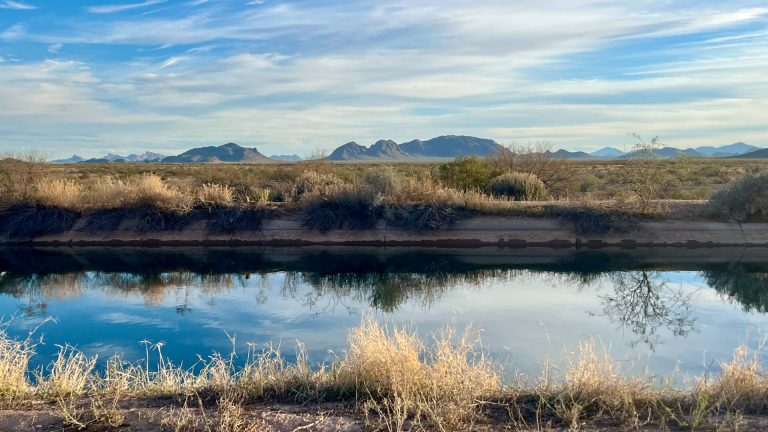
Rivers
You’ll be surprised at how often you’re following or crossing rivers on the GET. Some of the creeks can also swell enough that they seem like a river.
Gila River in Arizona
☢️ While you will follow the Gila River on the Arizona Trail for a brief time, you will not ford it, and it’s unsafe to drink.
Unfortunately, the section of the Gila River that overlaps with the Arizona Trail flows right underneath Ray Mine. The mine has polluted the river here to the extent that it is no longer safe to drink.
San Pedro River in Arizona
The San Pedro River looks more like a creek. Also, it’s fairly polluted by the nearby agricultural interests. That is, if it’s even running.
While it is a ford, don’t sweat on this one. It’s most likely ankle deep.
Blue River in Arizona


You’ll ford the Blue River before the Arizona/New Mexico border. Depending on the year, the Blue River can become treacherous. This is an excellent example of how fickle water in the desert can be.
After a high snow year, we crossed it in late April, and it was knee deep on me (I’m 5’2”).
In the weeks prior to our crossing, we saw reports of waist and chest deep.
San Francisco River in New Mexico
In New Mexico, you’ll cross the San Francisco River near Alma/Glenwood. The depth can often depend on snow melt.
Gila River West Fork, Middle Fork, & East Fork, New Mexico
You’ll also become well acquainted with the Gila River closer to its source. Fortunately, it’s less polluted there and totally drinkable with purification or filtration.
1️⃣ First, you’ll follow the West Fork Gila River. Much like following the Middle Fork on the Continental Divide Trail (CDT) alternate, you walk in and out of the river more times than you can count. Bring on the wet feet!
2️⃣ Second, after resupplying at Doc Campbell’s, you follow the Middle Fork Gila River on the CDT for a few miles. Prepare to get your feet wet, but not for too long!
3️⃣ Third, you’ll ford the East Fork Gila River only once.
The depth of the Gila River will depend on the previous year’s snowmelt in the spring. In the fall, it will depend on the summer monsoon season. Please, check before you enter so you’re not surprised.
Rio Grande


You have two choices when it comes to the Rio Grande River in New Mexico.
💦 First, you can cross at the bridge on a paved road. Most hikers prefer this route as it’s easier and safer. It’s directly on the Socorro Alternate. Also, you can access it from the main route by adding 7 miles.
💦 Second, you can ford it on the main route. The depth, width, and general grossness depend on the year and season. We opted for the bridge, adding 7 extra miles, because it was a swollen, muddy, fast river when we got there.
Major Creeks
After a high snow year, some major creeks will seem like rivers.


1️⃣ First, you’ll encounter Aravaipa Creek in Arizona if you manage to get permits ahead of time. I have personally seen the water levels swell while hiking Aravaipa Canyon in the early season.
2️⃣ Second, you’ll walk along (and in) Mineral Creek. Surprisingly, this canyon had beautiful walls and some fascinating mining history. After a high snow year, we had a few slippery crossings at the end of April. Previously, we saw reports that it was too high, and other thru-hikers took an alternate route.
3️⃣ Third, Eagle Creek presented something new. Here, locals drive their jeeps and ATVs back and forth through the wide creek for about 7-8 miles. In many places, the creek was as wide as a river and sometimes as deep.
4️⃣ Fourth, Willow Creek is a small mention. I was surprised at its depth when I saw its width. However, it runs below Mt. Baldy, which holds snow longer than many other areas of the Grand Enchantment Trail.
5️⃣ Lastly, you’ll cross Diamond Creek at least 40 times. You’ll cross it more if you take a recent alternate to avoid some of the most heavily burned portions of the Black Range (2022 fire).
All of these major creeks varied drastically depending on when you got to them. I cannot stress enough how much water in the desert can change and change quickly.


Springs
Every so often, you’ll get water from a spring. However, it’s not as common on the Grand Enchantment Trail as you’d think.
While many of them exist, you often don’t cross at their origin. To get this water in the desert, you’ll need to hike off-trail sometimes.
Pot Holes


Pot holes are one of my favorite sources in the desert. They’re usually bonus water after rainstorms.
You can find them where bedrock is on the surface in washes. Sometimes, you can also find them in slick rock.
Occasionally, they are deep enough to dip a bottle. Most times, they are very shallow.
💧 PRO TIP: Have an extra quart-sized Ziplock bag for dipping. For example, you can use the Ziplock in the shallower pot holes and then pour it into your dirty bottle to filter. 💧
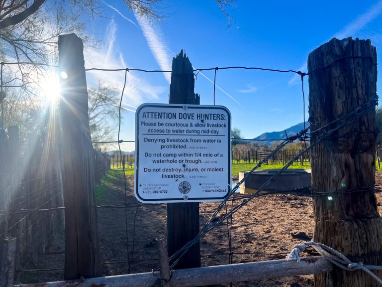
Cow Troughs with a Float Valve


There are different levels of gross when it comes to drinking cow water.
Surprisingly, most cow troughs with a float valve provide great water in the desert. Why? Because there is usually a pipe above the trough that fills when the float valve goes down.
Often, if you push GENTLY down on the float valve, you can hold your dirty water bottle to the pipe and get fresh (unfiltered) water.
⚠️ Please remember to use these carefully because ranchers depend on them working for their livestock. They can revoke access if hikers break them. ⚠️
Overall, float valves in cow troughs usually provide good water.
Occasionally, though, the pipe that contributes water is underneath the water line. Unfortunately, this means you must dip straight into the cow water. Two of these are pictured above.
Solar Well Cow Troughs


These cow troughs are slightly different than the ones with a float valve. A solar well cow trough depends on solar power to fill it.
Often, solar well cow troughs have replaced broken-down windmills. It presents a new opportunity for technology to bring water in the desert.
During the day, when it’s sunny, you’ll find these sources pleasant. They usually have a pipe above the trough, filling it with water.
However, if it’s a cloudy, rainy day or the sun has gone down, you won’t find anything flowing from the pipe. Here, you’ll need to dip right into the cow water.
Cow Tires


Then, there’s the good old cow tire. 🐄 More times than not, this is stagnant water held in a giant tire.
Usually, these are the grossest water sources. First, they’re almost always full of cow slobber. Second, they often have a green color. Third, the algae blooms can look disturbing.
These are the sources of water in the desert that will clog your filter fast.
If you’re lucky, a pipe is filling it, and you can grab it from the pipe without the algae.
Cow Tanks (Ponds)


Lastly, the grossest option of them all: the cow tank.
Essentially, a cow tank is a man-made pond for cattle. Because the cows literally walk into it to drink, it’s the most unsanitary.
For starters, cows drool when they drink. A lot.
Then, there’s the poop. Cows destroy water sources, including their own ponds by pooping in and at the edges of them.
💩 Yes, some of them are brown because they’re literally full of shit. 💩
Lastly, it’s hard to actually get water from them because the edges become muddy sinkholes. Because the ground slopes at such a low angle, you can’t always dip your bottle in easily. This means that you need to balance on a log or move a rock to the edge to reach farther.
That being said, sometimes there are no other options to get water in the desert. It’s a sad day when you need to filter from a cow tank.
🐮 PRO TIP: Have a small square of a bandana and “pre-filter” the water. If you’re alone, grab water with a Ziplock bag and pour the water through the bandana into your dirty bottle. This may save your filter some as you’ll take a lot of sediment and swimmers out before they enter your filter. 🐄
How Much Water Do You Carry Backpacking in the Desert?
The amount of water you should carry while backpacking will VARY.
💦 First, consider how much water you typically drink. Some people will need less water than others. Some people will need more.
💦 Second, consider how many miles you need to hike to your next water source. Is it extra hot out? Is it cold and windy? Remember, water in the desert can dry up. There are many seasonal-only water sources.
💦 Third, before you reach your next water source, do you need water to cook or cold soak?
That being said, I list a few tips below.
Rough 1 Liter Per 5 Mile Rule

If in doubt, try to carry about 1 liter for every 5 miles you need to hike to get to water.
This may be excessive for some and too little for others. Simply, it’s a good starting point.
Also, keep in mind weather considerations. You may need more water in the desert if its 90 degrees Fahrenheit or more 🥵. On the other hand, if it’s cloudy and cold, you may need less 🥶.
Have a Contingency Plan if a Water Source is Dry
Water in the desert can change drastically. You’d be surprised to know that water sources can dry up in the span of a week or two.
🤔 Therefore, when planning your water in the desert, look two sources ahead of where you are. Think, what happens if the next source is dry? How much farther do I need to hike? Is there an alternate off-trail source that is closer?
If the trail you’re on has a water report, pay attention to it. Even better, update it! If no one has updated in two weeks, update it. Update it even if your update is, “still running the same as X says below.”
Carry Extra for Cold Soaking or Cooking Meals
Plan water for cold soaking or cooking meals into your water carry, especially for the evenings.
Are you planning to dry camp? Do you have enough water to make dinner, breakfast, coffee, and drinking water to get you to the next source?
Make sure you know how much water to you need to cook or soak and add that in addition to your 1 liter per 5 miles estimate.
How long are the water carries on the GET?


Water carries depend on the year you hike AND the season. Therefore, there will be more water available directly after the first snowmelt in the spring or monsoons in the fall.
💧 The largest water carry that we encountered in the spring of 2023 was 27 miles.
💦 In contrast, the smallest water carries occur while you follow the rivers and creeks mentioned above. In those cases, you can carry about a half-liter at time and pick more up as needed during fords.
For example, we followed Turkey Creek (pictured above) for two miles. Then, the large container of water (also pictured above) was all we had for 10 miles.
On average though, you’ll often find 10-20 mile water gaps. This is standard for most desert trails.
Resources to Find Water in the Desert
➡️ You’ll find 3 main resources to figure out water on the GET. It’s reminiscent of the “old days” of thru-hiking where the information is a bit more scattered.
1️⃣ First, you’ll find a google sheets document for the current season water report.
2️⃣ Second, you can use the historical water report if the current year’s report has not been updated.
3️⃣ Lastly, you can use good old Far Out for the trail sections that use the Arizona Trail and the Continental Divide Trail.
More on each below…
Crowd-Sourced Grand Enchantment Trail Water Report
This data is crowd-sourced and updated as hikers pass and see water sources. If you use this source, please update it as you go through.
Because water in the desert can change often, even by a week, it’s important to keep it updated.
Don’t forget, if two weeks have passed and the water report is still good, you can update it saying, “previous report still good two weeks later.”
You can find that report here.
Historical Water
The historical water report is also crowd-sourced water information. However, it’s compiled from previous years to paint a picture of when sources are running.
This can prove helpful if you happen to hike before everyone or no one is updating the current water report. For example, if you begin hiking ahead of the pack, last fall’s information might be less accurate than the historical water report.
Water in the desert can prove very tricky and having multiple resources helps find it. You can find the historical water report here.
Far Out App for Overlap Sections with the Arizona Trail (AZT) & Continental Divide Trail (CDT)

If you’ve hiked any of the Triple Crown, you’re familiar with Far Out (formerly Guthook).
If you’re unfamiliar, it’s a GPS app for long-distance trails that embeds a water report. You’ll find water information by clicking on the water droplet icons and reading the comments. It’s often more updated than the GET water report.
You would need the Arizona Trail and the New Mexico CDT section. While pricy for the Grand Enchantment Trail’s use of either trail, it’s very helpful. By the time many hikers hike the GET, they’ve often already hiked both the AZT and CDT. Therefore, they will often update Far Out over the GET water report in these sections.
Safety Carrying Water in the Desert & Conclusion


In conclusion, err on the side of caution for carrying water in the desert on the Grand Enchantment Trail.
Know the snowpack from the previous winter if you’re hiking in the spring.
Know how the monsoon season went if you’re hiking in the fall.
Always think two water sources ahead in case one is dry, and you need a plan B. Sometimes you’ll have plentiful water, and other times you’ll have seasonal water.
Basically, try not to be as lackadaisical with water in the desert as you are on other trails. Think ahead and prepare. Have the right equipment, backflush your filter in every town, and try to have a pre-filter system for those nasty sources.


One Comment
Comments are closed.