Is the Continental Divide Trail Dangerous? Perspective of a 2x CDT Thru-hiker
As a perpetual long-distance thru-hiker, I often get asked: Is the Continental Divide Trail dangerous? This question frequently comes from those who have just finished hiking the Appalachian Trail or the Pacific Crest Trail.
The most common concerns include:
- The trail isn’t complete and has route finding.
- It goes above treeline often at high altitude.
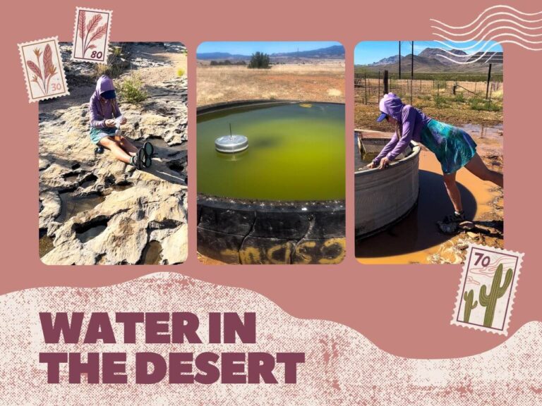
- The trail traverses desert areas with poor water sources.
- You need to be prepared for both heat and snow.
- It’s tougher overall than other trails.
However, the question is whether the CDT is dangerous…yes and no.
Below, I’ll discuss the dangers that I encountered on my southbound and northbound thru-hikes of the CDT AND how you can mitigate them to make it safe(r).
This post contains affiliate links. I have used every product mentioned, and if you purchase one of these products, I can make a small commission at no cost to you.
List of Contents
What is the Continental Divide Trail (CDT)?
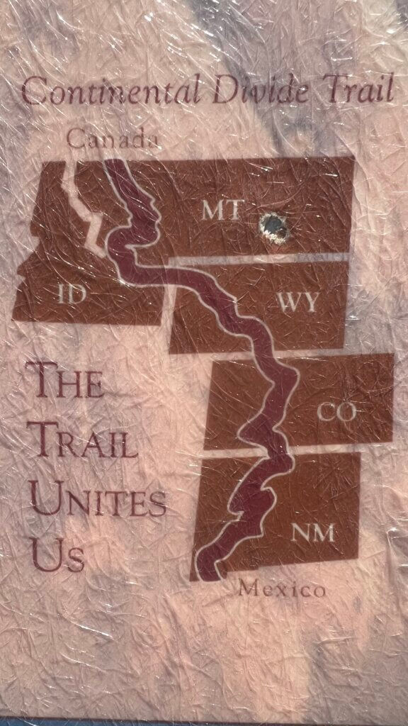
The Continental Divide Trail (CDT) is a long-distance trail that follows the backbone of the United States in the Rocky Mountains. Because the trail is still incomplete and there are many alternate routes, the total mileage can vary from 2,400 miles to 3,050 miles. It is a “choose your own adventure” trail.
At present, the CDT is roughly 95% complete.
I have hiked it twice: once southbound in 2015 and once northbound in 2022.
Where does the Continental Divide Trail Start and End?
Depending on the direction you begin, the trail starts/ends at the Mexican border and starts/ends at the Canadian border.
At the Mexican border, there are two options: the Crazy Cook Monument route and the Columbus Alternate route.
To get to or from the Crazy Cook Monument, you need to use a CDTC shuttle or have a high clearance vehicle with 4WD or AWD. It is a long and bumpy dirt road.
To get to or from the Columbus Alternate terminus, you can hire a car or get someone to drive you to the paved road border crossing. While the logistics to get here are easier, most thru-hikers go to the Crazy Cook Monument.
At the Canadian border, there are also two options: the Waterton Monument and the Chief Mountain Monument.
To get to/from the Waterton Monument, you must hike. Depending on the border situation, the closest way in and out is from the Canadian side (approx. 4.5 miles). From the US side, the closest way is from the other terminus, Chief Mountain (approx. 30 miles).
To get to/from the Chief Mountain Monument, you can drive along regular paved roads all the way to the border crossing. This option is becoming increasingly popular since the addition of a monument, and it is fewer miles if you take the alternate route from Many Glacier north. It can also be easier to get permits to take this alternate than the Highline trail in Glacier National Park.
Is the Continental Divide Trail Dangerous? How Do YOU Make it Safer?
The short answer: yes AND no. The Continental Divide Trail can BE dangerous. However, if you do your research and use adequate risk management, it can be just fine.
Here are the biggest dangers of thru-hiking the Continental Divide Trail and how YOU can make it safer.
Heat

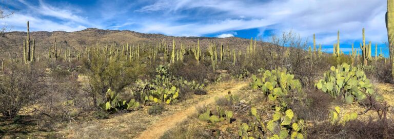
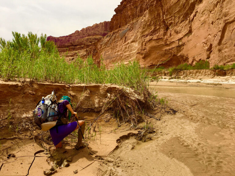
The Continental Divide Trail goes through significantly large sections of desert. Most of New Mexico is in a hot, high desert climate.
The most dangerous section of the CDT for heat is often the first section of the CDT for northbounders from the border to Lordsburg, NM. This low-lying section of desert contains very limited shade options and usually has the hottest temperatures.
Many nobo thru-hikers are just seeing the sun for the first time after a long winter and do not come prepared for the heat and sun exposure.
Serious issues that can arise from heat include:
- Heat Exhaustion
- Dehydration
- Hyponatremia
- Heat Stoke
But, how do you make the heat on the CDT safer?
- Heat exhaustion is often coupled with dehydration. It can happen easily and can be compounded over several days of exposure. The biggest tip I have for this is to opt to hike in the cooler temperatures. The desert is often quite cool in the mornings and evenings.
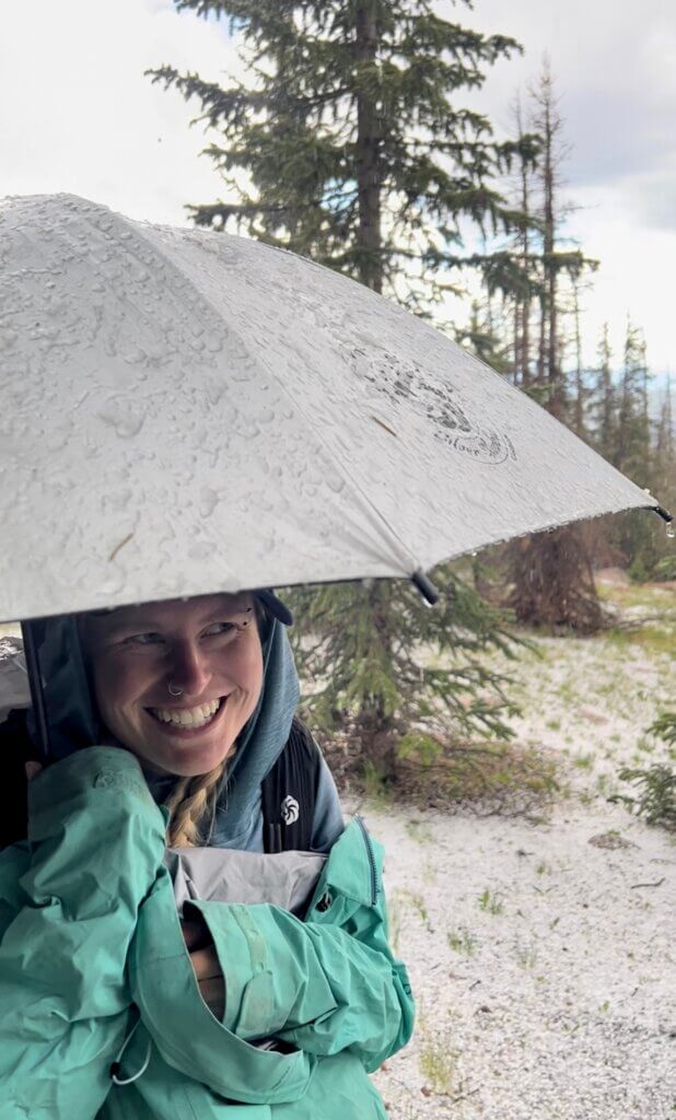
- To avoid heat exhaustion, choose to hike most of your miles during these two time periods, find shade for the hottest part of the day, and take an extended break. Furthermore, using clothing with SPF to cover your skin and a shade umbrella helps immensely.
- To avoid dehydration, drink an adequate amount of water. This will vary drastically between hikers due to varying body sizes. As a general rule, listen to your body. If you feel thirsty, you should drink water. You can also monitor your urine. If you are hydrated, your urine should be copious and light yellow. If it becomes infrequent and dark yellow, you need more water. Pay attention.
- Hyponatremia is overhydration with inadequate salt/electrolytes. In the desert, salty snacks and electrolytes are essential. I often carry out chips and salted nuts in desert hiking environments. I also carry Propel and Gatorade packets to add to my water to replace the electrolytes I lose in sweat.
- Heat Stroke usually happens when the signs of heat exhaustion and dehydration are ignored and not tended to in time. This is a serious medical issue that needs rapid evacuation. The biggest sign of heat stroke is a loss of consciousness.
Snow
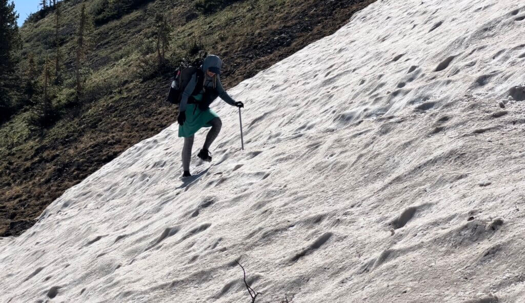
CDT nobo hikers will often encounter snow in Northern New Mexico, Colorado, and sometimes in Northern Montana.
CDT sobo hikers will most likely encounter snow in Northern Montana and possibly in Colorado and New Mexico.
The snow a thru-hiker will encounter depends on how early they start and how late they are still hiking.
Is snow on the Continental Divide Trail dangerous? It can be.
Dangerous snow situations that a thru-hiker might encounter on the CDT include:
- Steep snow traverses (where one must cross a steep snow slope laterally). This is the most common. One must know how to properly self-arrest using an ice ax.
- Avalanches. Much of the CDT crosses through avalanche terrain. It is important to check local avalanche forecast information before entering the terrain. Colorado has many resources for this, like this one.
- Deep snow. This can occur and be primarily problematic in the early spring thaw and the early winter large storms. Spring thaw is usually solid in the early mornings, then turns into a post-hole nightmare by the late mornings and afternoons. Early winter storm snow is often fluffy and deep where the snow has yet to solidify. Both are dangerous because they will drastically increase your calorie/energy output and slow your mileage down significantly.
- Lack of visibility during a snowstorm. Whiteout conditions are no joke. You will need to navigate with a GPS when you lose a visual on the trail and terrain around you. If your GPS is your phone, is it waterproof?
- Going snow blind. This is where the sun glare from the snow burns your eyes. You can go literally blind without the right precautions.
But, how do you travel safely through snow on the CDT?
The absolute best advice I can give you is to get snow backpacking experience FIRST, BEFORE you head out on your thru-hike.
- Know how much gear you need to get through the snow and how to use that gear. You should not be learning how to snowshoe or use an ice axe on trail. Learn how to traverse a snow field and self-arrest prior to your thru-hike. Do it without a backpack first, then with a backpack.
- Research avalanche forecasts ahead of time. Make a note in your phone of links to check before you leave town. Know how to read them by reading them for a month or more before you even hit the trail.
- Always have alternate routes and downloaded maps for alternate routes. Sometimes, you just can’t make the miles, or a traverse is just too sketchy for you. And, that’s ok! Just have multiple backup plans and bail-out options ready to go. Don’t be afraid to turn around if your closest backup plan or bail option is behind you. Live to see another day and come back to a section in the future when you can pick the season.
- If shit really hits the fan, set up your shelter and get inside. Periodically, hop out and knock the snow off of it so it won’t collapse. Ration your food. Have enough fuel to melt snow into water if you’re not close to a water source. From inside your tent, you can plan the best course of action with your dry sleep clothes on and in your dry sleeping bag.
- Have a Delorme InReach or Spot device. Pressing the S.O.S button should be a LAST RESORT OPTION. I recommend InReach specifically because you can send preset messages and custom text messages if you need to alert someone about your situation. This is great to tell your loved ones something like, “I’m ok, but delayed.” You can also message a contact you have in the area for non-emergency help, like a ride from a specific location that you have bailed out toward.
Lightning
Is lightning on the Continental Divide Trail dangerous? In my opinion, yes. Lightning is also the one thing every CDT thru-hiker will have to manage on a thru-hike at some point.
The continental divide of the United States is essentially the point at which water runs one way to the Pacific Ocean and the other way to the Atlantic Ocean. Thus, it is almost always on a ridge above the tree line.
While the CDT itself is not always on the literal divide, it often does follow it for miles at a time.
Therefore, a CDT hiker must manage hiking where lightning is most likely to strike: on the highest point.
On both my southbound and northbound hikes, one of the most frequent dangers I had to mitigate was lightning.
How did I do it?
- First, I studied my maps each night. I tried to hike as many sections above the tree line as possible in the morning. Thunderstorms in the Rocky Mountains (cough…Colorado…cough) usually happen in the afternoon between 1 pm-6 pm.
- Second, I knew where I could bail to uniform trees if I was on a ridge and a storm rolled toward me. This comes with having downloaded maps that exceed Far Out’s rather narrow window.
- Third, if a storm rolled in fast and I had no bail-down option, I set up my tarp and dove under it. Thus, the tarp could take the rain and hail while I stayed dry underneath.
- Fourth, if there was nowhere to set up a tarp, I would get into lightning position. This is squatting down, 20ft away from another person, with my umbrella up over me. I also avoid touching exposed tree roots. This serves to make yourself smaller and decrease the ground surface area that I am touching. Most lightning injuries occur from ground surface strikes that travel outward. I also avoid the tallest tree in an area and lakes or ponds.
River Crossings
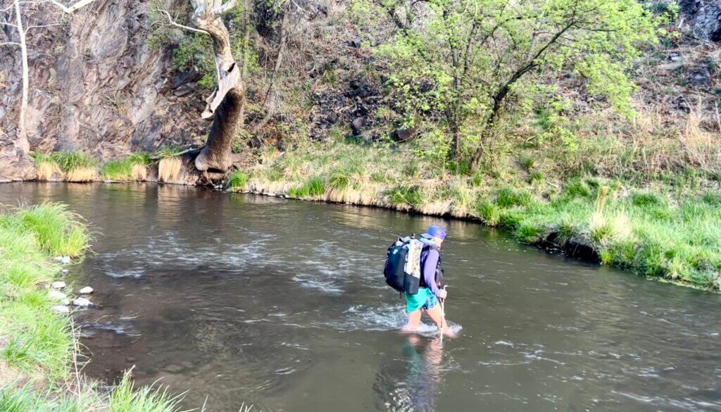
Surprisingly, fording rivers can be dangerous on the CDT. Rivers, creeks, and streams can become swollen with snowmelt water or large storm surges.
They can have temperatures barely above freezing or have strong currents.
Strainers downstream can suck you underwater and hold you there.
But, how do you cross a river safely?
- If there is a surge of water due to snowmelt, wait to cross in the morning. Snow thaws and melts in the afternoon, adding more water then. Overnight, it re-freezes, lessening the amount of water in a river. Literally, set up your tent and have an early night if you have to.
- Wait for more people to get there. River crossings are safer in groups. You can form one line behind the other with the tallest person facing upstream first. One person can yell “step,” so you all side step simultaneously. You could also link arms and cross side-by-side the same way.
- Check upstream and downstream for a safer spot. You DO NOT HAVE to cross where the trail tells you to cross. Sometimes, 100ft upstream or downstream has a better crossing point.
- Unhook your sternum strap from your backpack. If you lose your balance and go downstream, ditching your pack will be harder if you have to think about unhooking multiple things.
- Attach your InReach or Spot to your person in a secure clothing pocket. If you must ditch your pack, you will still have this on you to reach help.
Bears
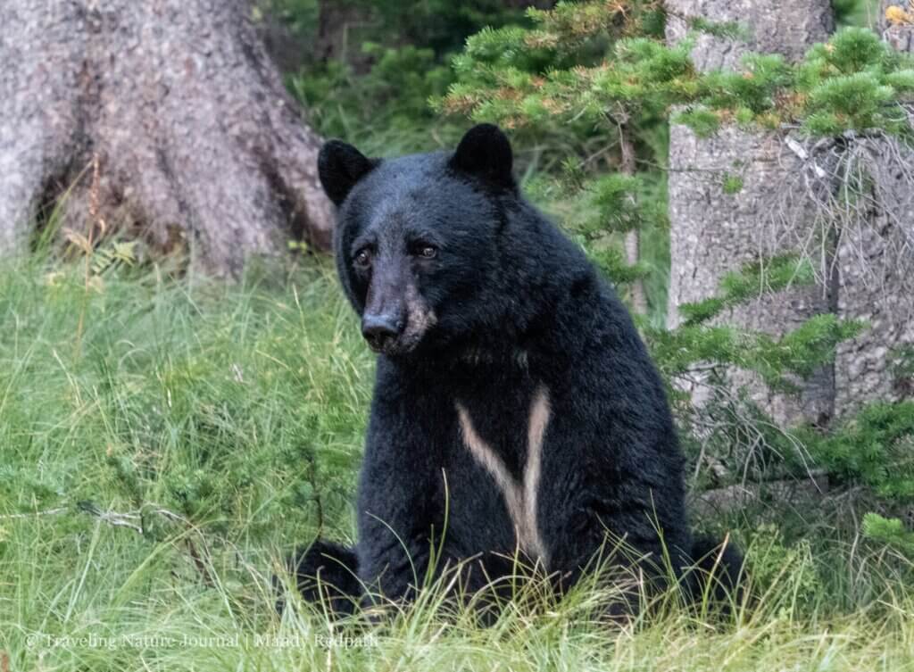
I understand this is a real fear for many people. However, it also drives me crazy when people ask me if I carry a gun for bears. NO. In fact, it is a HELL NO.
For a gun to work in killing or immobilizing a bear, it would have to be a large gun that I am not willing to carry. A handgun will not do shit when a bear is charging you.
Furthermore, a bear will not charge you if you exercise caution around bears.
So, are bears on the Continental Divide Trail dangerous? If you get between a mother and a cub, yes. If you cook inside your tent in grizzly country, yes. Most times, with proper precautions, no.
How to have a SAFE interaction with a bear:
- Give the bear space. You walk around a corner and oh shit, there is a bear. Say “hey bear” as you slowly back up. Do NOT run, but simply walk backward while talking to it. Bears often recognize the sound of a human voice and don’t want anything to do with you.
- If you’re in grizzly country, carry bear spray and have it handy. Practice drawing it quickly to make sure it’s ready when you need it. Bear spray is far more effective than a gun.
- Don’t cook where you camp in grizzly country. Cook your dinner for lunch and eat your lunch for dinner. Or, cook your dinner at a break around 5-6 pm, then hike another hour and have a small bar snack before you go to bed. That keeps the smelliest foods away from your camp.
- Properly store your food at camp, depending on location-specific requirements. Bear Vaults work great if a bear canister is required, and Ursacks work well otherwise. Good old-fashioned hanging-your-food-in-a-tree works if you have the right trees around and you’re good at throwing things.
Navigation
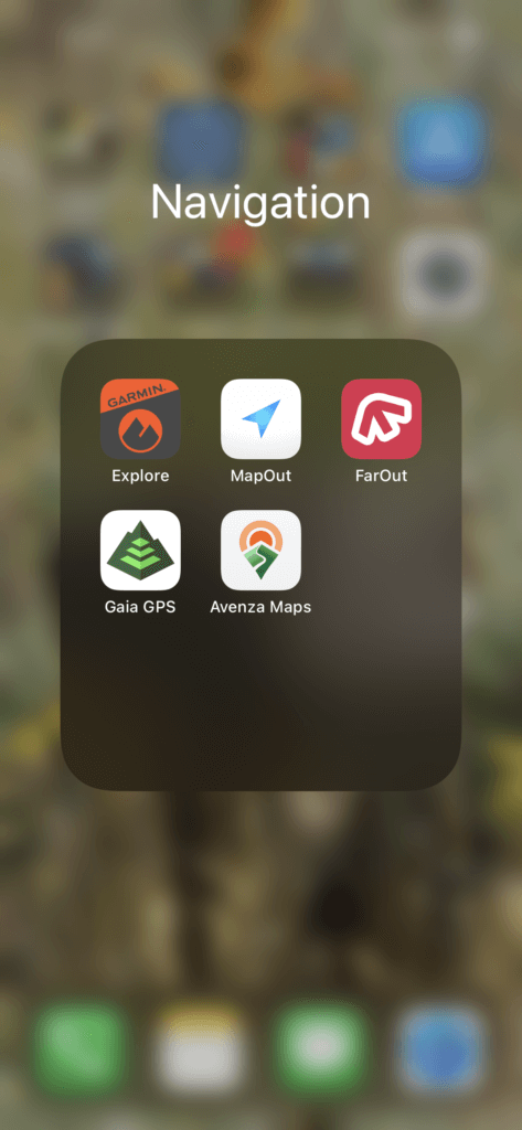
Navigation has become significantly easier with the increase in GPS technology. Far Out Guides has also made it simple in their app, where you can blindly follow the red line.
However, the CDT remains a trail where you SHOULD know how to:
- Read a topographic map
- Basic compass use
- Navigate off-trail
- Find your own bailout spots
WHY should you know how to navigate?
- Your phone could get water damage and cease to work. Paper maps or a partner with a working phone will be your backup.
- Phone batteries can die. Same with battery packs. Paper maps or a partner with a working phone will be your backup.
- You may not pay attention and walk clear out of Far Out Guides‘ narrow corridor of maps.
You can make your CDT experience safer if you have these navigational skills BEFORE you get to the CDT. You will have plenty of opportunities to improve these skills on trail, but knowing the basics beforehand is better. Start with these tips to learn off-trail navigation!
Conclusion
Is the Continental Divide Trail dangerous? Yes and No. It certainly has the recipe for dangerous situations. However, if you prepare beforehand, you can lessen those dangers significantly.
If you like this post and want to prepare ahead of time more, check out my post on how I prepare for a thru-hike.
I do not recommend the CDT as a first thru-hike unless you already have these skills from prior backpacking adventures.
Is it possible to thru-hike it and learn as you go? Yes. But it will be a more difficult experience.